
The Hunza valley sits west of the Central Karakoram National Park along the Karakoram Highway between Gilgit and the Chinese border at Khunjerab. It is not technically inside CKNP boundaries, but every visitor to the park spends time here — it is the most accessible piece of mountain country in northern Pakistan, the home of the Burusho people, and the visual postcard of Gilgit-Baltistan. We treat it as the western buffer of the park’s tourism economy.
Where the Hunza valley is
The Hunza valley runs north-east from Gilgit along the Hunza River, climbing past the historic centres of Karimabad and Aliabad, through Attabad Lake, and on toward Sost and Khunjerab Pass at the Chinese border. Nagar sits across the river from Hunza proper — same valley, different community, different denomination. Gojal is the upper-Hunza region beyond Attabad, home to the Wakhi communities of Gulmit, Passu, Sost and Shimshal.
Driving time: about 2.5 hours from Gilgit to Karimabad on the Karakoram Highway.
What the Hunza valley is famous for
Karimabad and Baltit Fort
Karimabad is the historic capital of Hunza state and the most-visited destination in northern Pakistan. Baltit Fort — the 700-year-old residence of the Mir of Hunza, restored by the Aga Khan Trust for Culture in the 1990s — sits on a ridge above the village. It is the most photographed building in Pakistan’s mountain regions. Below it, Altit Fort is older still (about 1,100 years), smaller, more atmospheric, perched on a cliff above the river.
Karimabad village itself has become the centre of Hunza tourism. Decent hotels, restaurants serving Hunza cuisine, walking access to Eagle’s Nest at Duikar (the sunrise viewpoint over Rakaposhi and Ultar) and the Ultar meadows above Baltit.
Rakaposhi (7,788 m) and Diran (7,266 m)
The two great peaks visible from Hunza. Rakaposhi rises in a clean 5,800-metre face directly above the valley — one of the steepest sustained mountain rises on earth. Diran is its smaller, snowier neighbour. Both have base camp treks accessed from the Bagrote and Nagar valleys. Day-trippers can stop at the Rakaposhi viewpoint on the KKH at Ghulmet for the postcard view.
Attabad Lake
Created in January 2010 by a massive landslide that dammed the Hunza River, drowning a section of the Karakoram Highway and cutting off Gojal for years. The new highway now tunnels around the lake. The lake itself is 21 km long and a strange turquoise blue. Boat rides, jet-skis (yes), and lakeside resorts have grown into a substantial tourism economy here over the past decade.
Passu Cones and the Gojal valley
North of Attabad, the upper Hunza valley (Gojal) opens into the Wakhi region. The Passu Cones — a row of granite spires above Passu village — are one of the iconic skylines of the KKH. The Passu Glacier’s snout is a 30-minute walk from the village. Beyond Passu, Sost is the last Pakistani town before the Khunjerab border.
Hopper Glacier (Nagar side)
One of the few glaciers in the Karakoram you can drive to the snout of. From Aliabad, an hour’s jeep drive takes you across the river into Nagar, up the Hopper valley, to the moraine of the Hopper Glacier. A 30-minute walk gets you to the active black ice. Day trip from Karimabad.
Shimshal valley
The most isolated inhabited valley in Pakistan, reached by a vertiginous jeep road from Passu. Shimshal village sits at 3,100 m and the valley climbs to over 4,000 m at Shimshal Pass. The Shimshalis are Wakhi-speaking Ismaili Muslims with one of the strongest mountaineering traditions in Pakistan — many of the country’s top high-altitude porters and climbers come from this single valley. Multiple multi-day treks possible from the village.
Ultar meadow + Ultar Glacier
Above Baltit Fort, a 4-hour walk takes you to the Ultar meadow at 3,300 m, with the snout of the Ultar Glacier and the south face of Ultar (7,388 m) immediately above. Possible as a long day-walk from Karimabad with an early start.
Burusho culture and the Ismaili dimension
The Hunza Burusho are predominantly Ismaili Muslim — followers of the Aga Khan, with a tradition of liberal religious practice, female education and openness to outsiders that has shaped Hunza’s tourism profile for decades. The Aga Khan Development Network has been a major presence in the valley since the 1960s, building schools, the restored forts, hospitals and irrigation. Hunza routinely posts Pakistan’s highest literacy rates — over 95% — including for women.
The Nagar Burusho across the river are predominantly Shia, more conservative culturally, less tourism-developed. The two communities are linguistically identical — both speak Burushaski — and culturally distinct.
Hunza food
Apricot in everything — fresh, dried, jam, oil-pressed, kernel-roasted. Sea-buckthorn juice (a regional speciality). Hunza bread (chapshuro — a stuffed flatbread). Walnuts, mulberry, locally-grown grapes, and a regional wine tradition that survives despite Islamic prohibition (small private production only). The buckwheat and millet staples shared with Baltistan also appear here.
Treks and side trips from Hunza
- Karimabad walking tour — Baltit Fort + Altit Fort + Eagle’s Nest, full day.
- Ultar meadow day walk — from Baltit, full day.
- Hopper Glacier day trip — from Aliabad, full day.
- Passu Cones + Passu Glacier walk — 1–2 days based out of Passu.
- Khunjerab Pass day trip — from Sost or Passu, the highest paved international border crossing in the world (4,693 m).
- Shimshal Pass trek — 7–10 days, demanding, one of the great Wakhi-area treks.
- Rakaposhi Base Camp trek — 4 nights from Minapin.
Practicalities
- Accommodation: Karimabad has the strongest hotel infrastructure (Hunza Serena, Eagle’s Nest, Hunza Embassy, Hard Rock-style boutiques and dozens of mid-range options). Passu and Gulmit have growing options. Shimshal is homestay-only.
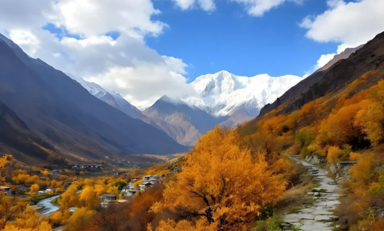
- Season: April–May for cherry / apricot blossom; June–September for general visiting and trekking; October for harvest and golden poplars; winter is cold but accessible by KKH.
- Roads: Karakoram Highway is well-maintained from Gilgit to the Chinese border. Side roads (Hopper, Shimshal, Naltar) are jeep-only.
- Connectivity: all networks work in Karimabad and Aliabad; Zong is best in Gojal; nothing in Shimshal valley past the village.
Why come to Hunza
If you have a week in Gilgit-Baltistan and you want one base, Karimabad is it. Cultural depth (Baltit Fort, Altit Fort, Burusho food and language), access to multiple side trips (Eagle’s Nest, Hopper, Passu, Khunjerab), realistic walking from village level into alpine country, and a tourism infrastructure that actually works for international visitors. Most CKNP visitors split time between Hunza and Skardu — we recommend at least 3 nights in each.
Related reading: our Cultures of the Karakoram page on Burushaski and the Wakhi communities, our Visiting CKNP page for getting to Hunza.