
Outside the Arctic and Antarctic, the Karakoram holds the largest concentration of glacier ice on the planet. Inside the Central Karakoram National Park — just inside our 10,557 km² boundary — we count the four longest non-polar glaciers in the world. We also count, every season, how each one is changing. Here’s what we know about the rivers of ice that define this park.
The big four
Siachen Glacier (75 km)
The longest glacier outside the polar regions, and a strange one in this list because most of its length sits across the Line of Control between Pakistan and India and is therefore a militarised, closed environment. The lower 15 km on the Pakistani side touch the eastern boundary of CKNP. No public access; mentioned for completeness.
Biafo Glacier (63 km)
Runs north-south from Snow Lake / Lukpe Lawo at the head, down through CKNP to the village of Askole. The Biafo + the Hispar Glacier together form the longest continuous mountain glacier system outside the polar regions — a single ice highway that connects the Baltistan side of the Karakoram to the Hunza side.
The Biafo–Hispar traverse — about 17 days and one of the great long ice walks of the world — goes up the Biafo, crosses Hispar La (5,151 m), and descends the Hispar to the village of Hispar in Nagar. It’s in our adventure treks category for a reason: technical glacier travel, crevasse danger, no infrastructure.
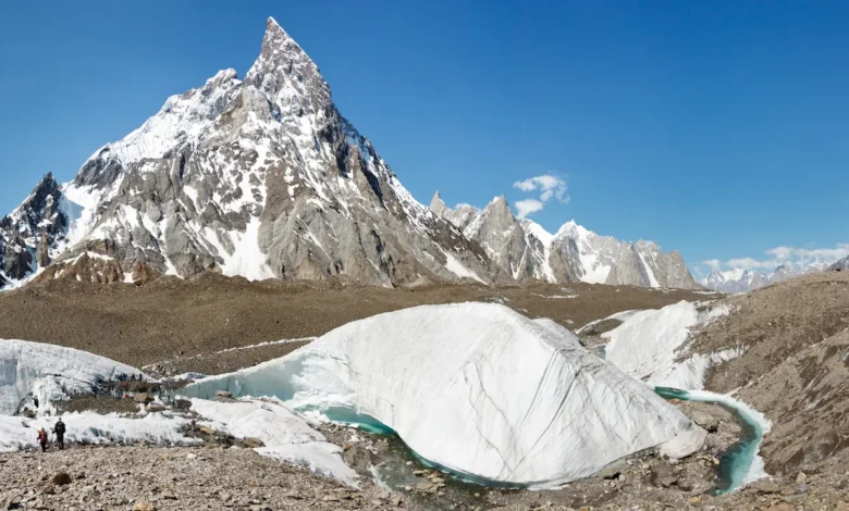
Baltoro Glacier (62 km)
The famous one. The Baltoro runs east-west from Concordia down to its snout at Paju. It’s a debris-covered glacier — the upper third clean ice, the lower two-thirds buried under metres of moraine that is itself a working surface for trekkers. This is the glacier you walk on for four days to reach K2 Base Camp.
Our SEED-funded mass-balance monitoring — in partnership with Italy’s Ev-K2-CNR Committee — suggests the Baltoro has been remarkably stable over the past two decades, with very slow snout retreat and mass largely sustained. This is the “Karakoram Anomaly” — the well-documented phenomenon of Karakoram glaciers behaving differently from neighbouring ranges (Hindu Kush, Pamir, Himalaya) where retreat has been pronounced. Why? The leading hypothesis is increased winter precipitation in the Karakoram driven by changes in the westerly flow. The Baltoro is one of the cleanest sets of evidence for it.
Hispar Glacier (49 km)
The west-flowing twin of the Biafo. Runs from Hispar La down through Nagar district to the village of Hispar. Less travelled than the Biafo, but the lower part — below Bitanmal — is a working pasture for the Nagar Burusho herders, and the upper part feeds Snow Lake / Lukpe Lawo, the great basin where five major glaciers converge.
The Godwin-Austen Glacier — the K2 approach
Roughly 18 km long and named for the surveyor Henry Haversham Godwin-Austen who mapped the upper Baltoro in 1861. It flows south from K2 to the Concordia junction. This is the moraine you walk up on the rest day from Concordia to stand at K2 Base Camp. Steeper and more crevassed than the Baltoro, but still rope-free for trekkers up to the base camp moraine.
The Snow Lake basin
Above the Biafo head sits one of the strangest topographies in the high Karakoram: Lukpe Lawo, “Snow Lake” — a vast accumulation basin of more than 80 km² where five major glaciers (Biafo, Sim Gang, Lukpe, Khurdopin, Braldu) converge. Eric Shipton called it “the last unexplored country” in the 1930s, and even today the basin’s upper reaches see only a handful of expeditions a year. The trekking traverse crosses the basin between Biafo and Hispar; mountaineering parties use it to access peaks like Workman Peak, Latok and the Ogre.
Why glaciers matter to the people downstream
Every village in CKNP and below it depends on glacier melt. The Indus — the river system that supplies water to 270 million people across Pakistan and parts of India — takes a substantial fraction of its summer flow from the Karakoram glaciers. The villages of Askole, Hushe, Shigar, Skardu and Hunza all run irrigation channels (kuhls) directly off glacier-fed streams; in Hunza you can still see Burusho infrastructure that was engineered around the glacier flow patterns of 200 years ago.
This is why CKNP’s mandate isn’t just “protect the mountains.” It’s “protect the water tower of Pakistan.”
Glacial hazards in the park
Working alongside the glaciers means living with their hazards:
- Glacial Lake Outburst Floods (GLOFs). Supraglacial lakes form on stagnating ice, fill, and release catastrophically. The Khurdopin Glacier surge in 2017 dammed the Shimshal River and produced a GLOF that we’re still seeing channel changes from. The Pakistan Meteorological Department and our team monitor several lakes year-round.
- Glacier surges. The Karakoram is the densest cluster of surge-type glaciers on earth — glaciers that suddenly speed up by an order of magnitude over a season or two, then quiet again. Hispar and the Khurdopin have surged in recent decades.
- Crevasses on covered ice. The lower Baltoro looks like moraine because it is buried in moraine, but the ice underneath is alive and the moraine cover hides serious crevasses near the snout and along the glacier’s margins. Stay on the established trail.
- Ice falls — particularly the Trango / Cathedral icefall and the lower Baltoro’s frontal cliffs. Don’t camp under them.
How to walk on a Karakoram glacier
If you’re trekking up the Baltoro, you don’t need crampons or a rope — you’re walking on rock-covered ice the whole way to Concordia, and the trail is well-marked by porter traffic. What you do need:
- Sturdy ankle-supporting boots; the moraine surface is uneven.
- Trekking poles — non-negotiable on the lower glacier.
- Good sunglasses (Cat 4 ideally) — UV at 4,000 m on ice is brutal even when overcast.
- Sunscreen on every exposed surface, including the underside of your nose.
- For glacier-traverse routes (Biafo–Hispar, Snow Lake, Khurdopin) you absolutely need crampons, ice axe, rope and crevasse-rescue training. These are mountaineering, not trekking.
What we’re watching
The Ev-K2-CNR scientific station at Urdukas (in partnership with the Italian National Research Council) runs continuous meteorological and glaciological monitoring on the Baltoro. Annual mass balance, surface temperature, summer melt rates, debris cover thickness, supraglacial pond formation. The dataset is one of the most complete in the high Asian glacier record. If you’re a researcher and you want access to it, our research-permit page is the entry point.
For more on the routes that take you onto these glaciers, see Classic Treks and Adventure Treks. For the wider park context, our About page.