
The Central Karakoram National Park exists on paper because of a 1993 declaration. It exists in practice because of a thirty-year scientific partnership between Pakistan and Italy, and because of a programme called SEED that put real infrastructure on the ground in valleys where almost no government work had reached. If you’ve walked the Baltoro and noticed that the campsites have toilets, that the rangers have radios, that there’s a meteorological station above Urdukas — that’s the work this conservation programme has paid for. Here’s the story.
How CKNP came to be
The idea of protecting the high Karakoram was first raised seriously in the 1980s, when increased international climbing traffic on K2 and the Baltoro made the environmental cost — abandoned camp gear, human waste, rope and ration debris from one season piling up against the next — impossible to ignore. The Pakistan Government declared the park in March 1993, with boundaries that took in 10,557 km² across four districts of what was then the Northern Areas (renamed Gilgit-Baltistan in 2009).
The declaration created a legal protection framework but no working management body, no rangers, no operating budget. For the first decade after declaration, the park existed mostly as a line on a map.
Enter Ev-K2-CNR
In 1986 the Italian climber-scientist Ardito Desio — the same Desio who led Italy’s 1954 first ascent of K2 — founded the Ev-K2-CNR Committee (named for Everest, K2, and Italy’s National Research Council, the CNR). Its mandate was high-altitude scientific research; it built the Pyramid Laboratory on the Nepali side of Everest in 1990 and started looking at the Karakoram next.
Through the late 1990s and early 2000s Ev-K2-CNR established a working relationship with the Government of Pakistan: scientific stations on the Baltoro, climate research, glaciological monitoring. By 2005 the relationship had matured into a full development partnership. The instrument was a programme called SEED.
What SEED actually did
SEED — Social, Economic and Environmental Development — ran from 2005 through to the late 2010s, funded primarily by the Italian Ministry of Foreign Affairs and Cooperation through Ev-K2-CNR. Its budget was modest by international development standards (in the range of EUR 5–8 million across the programme’s lifetime) and its output, by the same standards, was unusually concrete. Among the things SEED built or established:
Park management infrastructure
- The CKNP Directorate’s working office in Skardu, including its scientific library and the GIS mapping unit.
- A radio communications network covering the buffer zone and the major trekking corridors.
- The ranger training programme — in partnership with the Wildlife Department of Gilgit-Baltistan — that produced the first generation of CKNP rangers.
- The visitor checkpoints at Askole and Hushe.
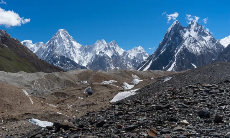
Baltoro environmental management
- Designated and serviced campsites at Paju, Urdukas, Goro II and Concordia — toilet pits, marked tent zones, waste collection.
- The porter-led waste-evacuation system that walks expedition rubbish back down the glacier.
- The Pyramid Laboratory station at Urdukas: a permanent meteorological and glaciological monitoring point continuously logging temperature, precipitation, glacier surface velocity and mass balance — one of only a handful of such datasets in the high Asian glacier record.
Community programmes
- Drinking-water schemes in 14 buffer-zone villages that previously drew unfiltered water directly from glacier streams.
- The Italian K2 Museum in Skardu and the Askoli Museum at the Baltoro trailhead — cultural infrastructure that doubles as visitor interpretation.
- Community-conservancy programmes for ibex and markhor (the trophy-hunting model that turned village interest into population recovery).
- Vocational training in the buffer-zone villages for guiding, portering and cooking certifications.
Scientific monitoring
The CKNP/Ev-K2-CNR research portfolio has produced peer-reviewed work on the Karakoram Anomaly (the puzzling pattern of stable or growing Karakoram glaciers in a warming climate), high-altitude meteorology, snow leopard population modelling, and long-term land-cover change in the buffer zone. The dataset from Urdukas alone is one of the longest continuous high-altitude meteorological records in Pakistan.
Where the programme stands now
SEED in its original Italian-funded form wound down at the end of the 2010s. The infrastructure it built — the offices, the ranger network, the campsite waste system, the monitoring stations — is now operated by the CKNP Directorate as part of regular park operations, paid for from the park’s entry fees, the Gilgit-Baltistan tourism budget, and intermittent international research grants.
That hand-over has been imperfect. Maintaining a meteorological station at 4,000 m on a glacier requires money and skilled personnel, and both are tighter now than they were in 2010. We’re actively looking for new partnerships; if you’re a researcher or an institution interested in continuing the Karakoram dataset, the contact details are at the bottom of this page.
Why this matters — and why it’s a model
Most national parks in mountain Asia were imposed top-down, with mixed results: lines drawn on maps in capital cities, rules announced, communities resentful and rangers under-resourced. The CKNP / SEED experience demonstrated something different. By tying environmental protection to community infrastructure (water, education, vocational training, the trophy-hunting income model), and by tying scientific work to cultural centres that local people use, the park got both legitimacy and a working economy.
The community-conservancy hunting model alone, controversial as it is, has reversed the markhor decline in the Astore valley. Ibex populations across the park’s southern edge are stable or growing. Snow leopard sightings — through camera trap evidence rather than direct observation — are at their highest in our records. None of this is easy and none of this is settled, but on its own terms the model has delivered.
The conservation challenges ahead
- Climate. The Karakoram Anomaly may not last. If the westerly precipitation patterns that have kept these glaciers stable shift, the change will be very fast and very visible.
- Tourism pressure. Pakistani domestic tourism in Gilgit-Baltistan has roughly tripled since 2018. Hunza and Skardu can absorb it; the Baltoro can’t. We’re actively considering capacity caps for the Baltoro corridor.
- GLOFs. Glacial Lake Outburst Floods are increasing in frequency, and our monitoring capacity needs to scale with them. Each event downstream costs lives.
- Funding. The single largest risk to the park’s working operation is sustained funding for ranger salaries, monitoring stations and waste management. Tourism revenue alone is not enough.
How to support the park
If you visit, pay the park fee — not just the operator’s package fee, the actual park fee that goes to the Directorate. Hire your porters in Askole or Hushe, not in Skardu. Buy from local shops in the villages. Use the toilet pits at the campsites. Carry out everything you bring in. Tell us what you saw; reports of wildlife and environmental issues are genuinely useful.
If you’re a researcher, our research-permit process is the entry point for collaborative work. If you’re an institution interested in funding the next generation of Karakoram environmental monitoring, we’d be very pleased to hear from you.
Contact
Directorate of Central Karakoram National Park
Sadpara Road, Skardu, Gilgit-Baltistan, Pakistan
Tel: +92-5815-921018 — Email: [email protected]
Related reading: About the park, Visitor services, Wildlife of CKNP.